 Skarp
SkarpChapter 10 of 23
Weather Briefings and METAR Decoding
A compact METAR can reveal winds, visibility, ceiling, precipitation, temperature, pressure, and rapidly changing hazards. Token-by-token decoding turns the report from a string of abbreviations into a go/no-go decision tool.
1. Build a Briefing, Not Just a METAR
A METAR Is a Snapshot
A METAR is a coded surface observation at one station and one UTC time. It is a critical input, but it cannot by itself provide a complete go/no-go decision.
Classify Every Product
- Observations: METAR, radar, satellite
- Forecasts: TAF and graphical forecasts
- Advisories: SIGMET, G-AIRMET, CWA
- PIREPs: pilot-reported conditions
Brief Broad to Narrow
Use FAA Flight Service and National Weather Service Aviation Weather Center products. Review the area, route, launch site, and operating time, then compare multiple sources.
2. A Practical Internet Briefing Workflow
Start With the Mission
Define the launch site, operating area, maximum altitude, time window, route, and recovery options. Weather is operational only when compared with the mission.
Use UTC and Trends
Aviation times use `Z` for UTC. Compare current METARs, nearby stations, radar, and satellite with forecasts for the actual operating window.
Part 107 Weather Minimums
During flight: at least 3 statute miles visibility from the control station, 500 feet below clouds, and 2,000 feet horizontally from clouds. More restrictive aircraft limits still apply.
3. Read a METAR in Report Order
The Fixed Pattern
`type → station → time → modifiers → wind → visibility → RVR → weather → sky → temperature/dew point → altimeter → remarks`
Time and Wind
`281753Z` means day 28 at 1753 UTC. `34012G20KT` means wind from 340 degrees true, 12 knots, gusting to 20 knots.
Do Not Skip the End
`12/08 A3010 RMK AO2` gives temperature/dew point, altimeter, and remarks. `AO2` indicates an automated station with a precipitation discriminator.
4. Worked Decode: A Rapidly Deteriorating Report
Why `SPECI` Matters
`SPECI` KABC 281835Z is a special observation at 1835 UTC. A newly issued special report can reveal a rapid change that an older routine METAR misses.
Wind and Visibility
`22015G26KT 180V250 2SM` means gusts to 26 knots, a 70-degree wind-direction range, and only 2 SM prevailing visibility.
Hazards and Ceiling
`+TSRA BR BKN008 OVC025` means heavy thunderstorm rain and mist. The ceiling is 800 feet AGL, from the lowest `BKN` layer.
Operational Decision
This report is no-go: 2 SM is below the Part 107 visibility minimum, while thunderstorms, heavy rain, low clouds, and gusts add independent hazards.
5. Turn Wind Groups into UAS Implications
Wind Is From
`09012KT` means wind from 090 degrees true at 12 knots. `00000KT` is calm; `VRB03KT` is variable direction at 3 knots.
Calculate Components
Angle between wind and track:
`headwind = speed × cos(angle)`
`crosswind = speed × sin(angle)`
Use both steady wind and gust values.
The UAS Reality
A METAR samples wind at one surface station. Buildings, terrain, trees, and altitude can produce stronger or more turbulent wind at your actual flight location.
6. Wind Check
A METAR contains `27018G28KT`. Your planned aircraft track is 360 degrees. Which interpretation is best?
A METAR contains `27018G28KT`. Your planned aircraft track is 360 degrees. Which interpretation is best?
- Wind is from the west, producing about an 18-knot crosswind with gusts up to about 28 knots.
- Wind is toward the west, producing an 18-knot headwind with 28-knot gusts.
- Wind is from the north, producing an 18-knot crosswind.
- Wind is calm because the direction is perpendicular to the track.
Show Answer
Answer: A) Wind is from the west, producing about an 18-knot crosswind with gusts up to about 28 knots.
`270` means wind from 270 degrees true, or from the west. A northbound 360-degree track is 90 degrees from that wind, so the wind is essentially all crosswind: 18 knots steady and up to 28 knots in gusts.
7. Visibility, RVR, and Present Weather
Flight Visibility vs. RVR
`3/4SM` is prevailing station visibility. `R18/2400FT` is runway 18 visual range. RVR is runway-specific and does not substitute for Part 107 flight visibility.
Build the Weather Code
Read weather as intensity/proximity → descriptor → phenomenon. Example: `+TSRA` = heavy thunderstorm rain; `-SHRA` = light rain showers.
Fog, Mist, and Thunderstorms
`FG` is fog, `BR` is mist, and `VCTS` means thunderstorms in the vicinity. Even nearby convection can produce outflow gusts and quickly changing conditions.
8. Sky Condition, Ceiling, and Cloud Clearance
Read Height in Hundreds
`BKN012` is broken clouds at 1,200 feet AGL. `OVC040` is overcast at 4,000 feet AGL. The digits represent hundreds of feet.
What Counts as a Ceiling?
The ceiling is the lowest `BKN`, `OVC`, or `VV` layer. `FEW` and `SCT` do not create a ceiling, even when they are low.
Apply Part 107
There is no stand-alone Part 107 ceiling minimum. Maintain 500 feet below clouds and 2,000 feet horizontally from them, plus 3 SM flight visibility.
9. Temperature, Pressure, Remarks, and Report Limits
Corrected and Calm
`COR` means corrected and replaces the earlier version. `00000KT` is calm. `1/2SM FG VV002` means fog, one-half-mile visibility, and a 200-foot vertical-visibility ceiling.
Moisture Clue
`04/04` has a 0 C temperature-dew point spread: near-saturated air. It supports fog concern but must be evaluated with trends, wind, terrain, and forecasts.
Remarks Add Precision
`A3006` is altimeter 30.06 in Hg. `SLP176` is sea-level pressure 1017.6 hPa. `T00440044` supplies temperatures to tenths of a degree Celsius.
Know the Limits
Compare observation time with current UTC. `AUTO`, `AO1`, `AO2`, `COR`, and `NIL` affect how you interpret availability, automation, correction, and completeness.
10. Full METAR Decision Quiz
Decode the key operational facts before selecting an answer:
`METAR KLMN 281900Z 12008KT 4SM BR SCT006 BKN015 22/20 A2998 RMK AO2`
Which statement is correct for this report?
- The ceiling is 600 feet AGL, and the operation meets Part 107 visibility requirements.
- The ceiling is 1,500 feet AGL, and 4 SM reported visibility is above the Part 107 minimum, although mist and a small spread warrant caution.
- There is no ceiling because both cloud layers are below 2,000 feet AGL.
- The 12008KT group means wind is toward 120 degrees at 8 statute miles per hour.
Show Answer
Answer: B) The ceiling is 1,500 feet AGL, and 4 SM reported visibility is above the Part 107 minimum, although mist and a small spread warrant caution.
`SCT006` is scattered at 600 feet and does not form a ceiling. `BKN015` is broken at 1,500 feet, so it is the ceiling. `4SM` exceeds the 3 SM Part 107 visibility minimum, but `BR` and the 2 C temperature-dew point spread signal moist conditions that deserve trend monitoring. Wind is from 120 degrees true at 8 knots.
11. Rapid Recall: METAR Essentials
Flip each card, answer aloud, then revisit any weak card in your spaced review queue. The next mock exam will pressure-test weather decoding under time constraints.
- What does `281753Z` mean?
- The 28th day of the month at 1753 UTC. The `Z` indicates UTC, also called Zulu time.
- What is the difference between METAR and SPECI?
- A METAR is a routine aviation weather observation. A SPECI is a special observation issued when significant specified changes or conditions occur.
- What does `22015G26KT` mean?
- Wind from 220 degrees true at 15 knots, gusting to 26 knots.
- What is a METAR ceiling?
- The lowest reported broken (`BKN`), overcast (`OVC`), or vertical visibility (`VV`) layer. Few and scattered layers are not ceilings.
- What does `VV003` mean?
- Vertical visibility of 300 feet into an obscuration. It is a ceiling.
- What does Part 107 require for weather?
- At least 3 statute miles flight visibility from the control station, at least 500 feet below clouds, and at least 2,000 feet horizontally from clouds.
- What is the difference between `FG` and `BR`?
- `FG` is fog. `BR` is mist. Both are obscurations and can reduce visibility.
- What do `AUTO`, `COR`, and `NIL` signal?
- `AUTO` identifies an automated observation; `COR` means corrected; `NIL` means the observation is unavailable.
Figure 12 — METAR examples
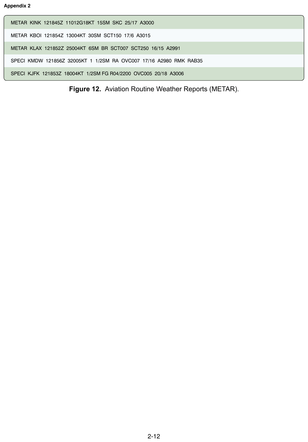
FAA-CT-8080-2H Figure 12. Decode KMDW and KJFK from the very METARs the exam presents.
Key Terms
- RVR
- Runway visual range, a runway-specific measurement of visibility along a runway.
- TAF
- Terminal Aerodrome Forecast, a coded forecast for conditions near an aerodrome during a stated period.
- UTC
- Coordinated Universal Time, the time standard used in aviation weather reports and forecasts.
- METAR
- A routine coded aviation weather observation for a station at a stated UTC time.
- SPECI
- A special coded aviation weather observation issued when specified significant changes or conditions occur.
- PIREPs
- Pilot reports that provide firsthand observations of weather and flight conditions.
- ceiling
- The lowest reported broken, overcast, or vertical-visibility sky layer.
- altimeter setting
- A pressure value used to set an altimeter; U.S. METARs encode it with `A` followed by four digits in inches of mercury.
- flight visibility
- Visibility from the control station during the operation; under Part 107 it must be at least 3 statute miles.
- temperature-dew point spread
- The numerical difference between air temperature and dew point; a small spread indicates air closer to saturation.