 Skarp
SkarpChapter 7 of 23
Class E, Class G, Special-Use, and Other Airspace
Not every boundary on a chart means the same thing, and not every hazardous area requires the same pilot response. This chapter separates regulatory restrictions from advisory cautions across the less familiar portions of the National Airspace System.
1. Start With the Operational Question
Ask the right question
For every chart boundary, decide whether it creates an ATC authorization requirement, requires agency permission, prohibits entry, or is only an advisory hazard.
Part 107 rule
Under `14 CFR 107.41`, prior ATC authorization is required in Class B, C, D, and Class E airspace designated for an airport.
Critical Class E distinction
Only surface-area Class E triggers the Part 107 ATC-authorization rule. Class E beginning at 700 or 1,200 feet AGL does not by itself require it.
Layer your analysis
Identify the class at flight altitude, check overlays and activity status, then apply the effect: authorization, permission, avoidance, or heightened vigilance.
2. Class E: Read the Floor, Not Just the Color
Class E has different floors
Class E is controlled airspace, but its floor varies. On sectional questions, determine where it begins, not merely whether a Class E symbol is nearby.
Surface Class E
A dashed magenta boundary means Class E begins at the surface. For Part 107, operations inside it require prior ATC authorization.
Transition areas
A faded magenta vignette means Class E begins at 700 feet AGL. A faded blue vignette means it begins at 1,200 feet AGL.
Common exam trap
At 200 feet AGL beneath a 700-foot Class E transition area, the operation is in Class G unless another airspace layer or restriction applies.
3. Chart Workflow: Class E or Class G?
Step 1: Find the launch point
Locate the planned launch point precisely. A boundary may be near an airport but not include your site; do not decide from airport proximity alone.
Example A: Dashed magenta
Inside a dashed magenta boundary, Class E starts at the surface. A 300-foot AGL Part 107 operation requires prior ATC authorization.
Example B: Faded magenta
Inside faded magenta, Class E starts at 700 feet AGL. At 300 feet AGL, the drone is in Class G; the vignette alone does not require authorization.
Use AGL correctly
Class E floors shown as 700 or 1,200 feet are AGL. Compare your operating altitude to terrain, not to an airport elevation or MSL altitude.
4. Prohibited, Restricted, and Warning Areas
Prohibited Area: P-
A `P-` area prohibits aircraft flight to protect sensitive interests. Treat it as a no-go area unless a specific applicable authorization permits entry.
Restricted Area: R-
An `R-` area contains unusual, often invisible hazards. When active, authorization from the controlling agency is required before entry.
Warning Area: W-
A `W-` area is generally over international waters beyond three nautical miles from the U.S. coast. It warns of hazards; it is not an automatic permission gate.
Read the details
For restricted areas, use the sectional and Chart Supplement to check boundaries, altitudes, times of use, controlling agency, and current activity status.
5. MOAs, Alert Areas, and Controlled Firing Areas
MOA: Military Operations Area
VFR traffic may enter an MOA, but extreme caution is appropriate. Military training can involve high speed, abrupt maneuvers, formations, and low-altitude activity.
Remote-pilot decision
An MOA does not automatically require Part 107 authorization. Contact the controlling agency for activity status and avoid the mission when collision risk is unacceptable.
Alert Area
An Alert Area marks high training volume or unusual aerial activity. It is advisory, but every pilot remains responsible for see-and-avoid and safe separation.
Controlled Firing Area
CFAs are not charted. Hazardous activity stops when surveillance detects an aircraft, unlike a restricted area where entry authorization is required when active.
6. Other Charted Hazards and Services
MTR numbering
`IR` means IFR route and `VR` means VFR route. Three digits indicate operations below 1,500 feet AGL; four digits indicate segments at or above 1,500 feet AGL.
TRSA and NSA
A TRSA is not an airspace class; underlying airspace controls. An NSA requests voluntary avoidance, though mandatory restrictions may be imposed when needed.
Advisory areas and VFR routes
An Airport Advisory Area supports FSS advisory service. Published VFR routes help crewed aircraft navigate; neither label alone creates a Part 107 authorization rule.
Parachute hazard
Jump areas combine climbing aircraft, rapid descents, parachutists under canopy, and ground activity. Treat them as a major operational hazard, not a simple chart icon.
7. Decision Drill: Choose the Operational Effect
Sort each situation before looking at the answer
For each situation, choose one response category:
- ATC authorization required
- Agency permission required when active
- Do not enter
- Heightened vigilance / assess and avoid
- Your site is within a dashed magenta boundary, and the flight will be at 250 feet AGL.
- Your site is within faded magenta shading only, and the flight will be at 350 feet AGL.
- The site lies inside an active `R-` area.
- A three-digit `VR` route crosses the site at low altitude.
- A `P-` area covers the site.
- The site is inside a charted Alert Area.
Self-check
- ATC authorization required.
- Heightened vigilance / assess other hazards; the Class E floor is 700 feet AGL, so the flight is below it in Class G.
- Agency permission required when active.
- Heightened vigilance / assess and avoid; low-level military VFR traffic is a serious collision hazard.
- Do not enter.
- Heightened vigilance / assess and avoid.
Notice the pattern: a chart feature can be operationally serious without being a Part 107 authorization boundary.
8. Quiz: The Class E Floor
Select the best answer
A remote pilot plans to fly at 300 feet AGL inside an area shown by a faded magenta vignette on a sectional. No dashed magenta boundary, other controlled airspace, TFR, or special-use area applies. What is the correct conclusion?
What is the correct conclusion?
- ATC authorization is required because all Class E airspace requires authorization.
- ATC authorization is required because faded magenta depicts Class E at the surface.
- The operation is below the 700-foot AGL Class E floor, so it is in Class G and does not require authorization solely for that vignette.
- The operation is prohibited because faded magenta depicts a restricted area.
Show Answer
Answer: C) The operation is below the 700-foot AGL Class E floor, so it is in Class G and does not require authorization solely for that vignette.
Faded magenta depicts Class E beginning at 700 feet AGL. At 300 feet AGL, the aircraft is below that floor in Class G. Under 14 CFR 107.41, the relevant Class E authorization requirement applies to Class E airspace designated for an airport at the surface, not to a transition area above the operation.
9. Flashcards: Symbols to Operational Effects
Flip each card, then say the operational effect aloud before checking the back.
- Dashed magenta boundary
- Class E beginning at the surface. A Part 107 operation within it requires prior ATC authorization under 14 CFR 107.41.
- Faded magenta vignette
- Class E begins at 700 feet AGL. Airspace below the floor is Class G unless another airspace layer applies.
- Faded blue vignette
- Class E begins at 1,200 feet AGL. Airspace below the floor is Class G unless another airspace layer applies.
- P- area
- Prohibited Area. Do not plan entry unless a specific applicable authorization permits it.
- R- area
- Restricted Area. Contains unusual, often invisible hazards; authorization from the controlling agency is required when active.
- W- area
- Warning Area, generally over international waters. Hazard warning requiring careful assessment, not an automatic permission requirement.
- MOA
- Military Operations Area. VFR entry is not automatically prohibited, but extreme caution and activity-status checking are appropriate.
- VR-123 versus IR-1234
- VR is a VFR Military Training Route; IR is an IFR route. Three digits indicate below 1,500 feet AGL; four digits indicate segments at or above 1,500 feet AGL.
10. Build a Preflight Airspace Brief
Practice a real mission-planning sequence
Imagine a construction-site mapping mission at 200 feet AGL. The sectional shows the site is outside controlled-airspace boundaries but near a parachute symbol. A `VR-125` MTR is charted nearby. The Chart Supplement lists parachute operations during daylight hours on weekends, and today is Saturday.
Work through this checklist:
- Classify the launch airspace at 200 feet AGL. If no controlled-airspace boundary reaches the surface, it is likely Class G.
- Identify overlays and published hazards. Here, parachute activity and a low-altitude MTR are separate hazards even though neither is automatically an ATC-authorization requirement.
- Interpret the timing. The published weekend daylight parachute note applies today.
- Assess the collision environment. Look for jump aircraft, parachutists, recovery vehicles, and fast military aircraft; remember that a drone may be difficult for crewed pilots to see.
- Choose a mitigation. Reschedule, relocate, coordinate with the drop zone, reduce the operating area, or cancel if safe separation cannot be assured.
The strongest answer is not "Class G, therefore launch." The strongest answer is: Class G may remove the ATC authorization requirement, but known parachute and military-route hazards can still make the operation unsafe.
11. Quiz: Special-Use Airspace Decisions
Select the best operational response
A remote pilot wants to inspect a utility corridor inside a charted MOA. The controlling agency reports that the MOA is active with military training. The location is otherwise Class G, and no TFR applies. What is the best answer?
What is the best operational response?
- Launch without further consideration because MOAs never affect VFR operations.
- Request Part 107 ATC authorization because every MOA is controlled airspace.
- Recognize that entry is not automatically prohibited, but avoid or postpone the operation if active military training creates an unacceptable collision risk.
- Treat the MOA as a Prohibited Area and never operate there.
Show Answer
Answer: C) Recognize that entry is not automatically prohibited, but avoid or postpone the operation if active military training creates an unacceptable collision risk.
An MOA separates military training activities from IFR traffic; VFR operations are not automatically prohibited. However, active military operations can create significant collision risk. For a small UAS, the sound operational decision is to assess the activity and avoid or postpone when safe integration cannot be assured. A MOA is not itself a Part 107 ATC-authorization category.
Figure 21 — Sectional chart excerpt
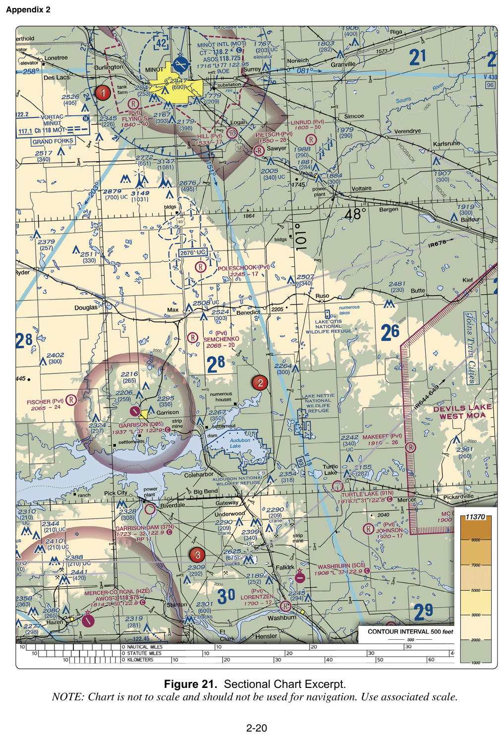
FAA-CT-8080-2H Figure 21. Exam questions locate airports on this excerpt by latitude and longitude.
Figure 59 — Military training routes on a sectional
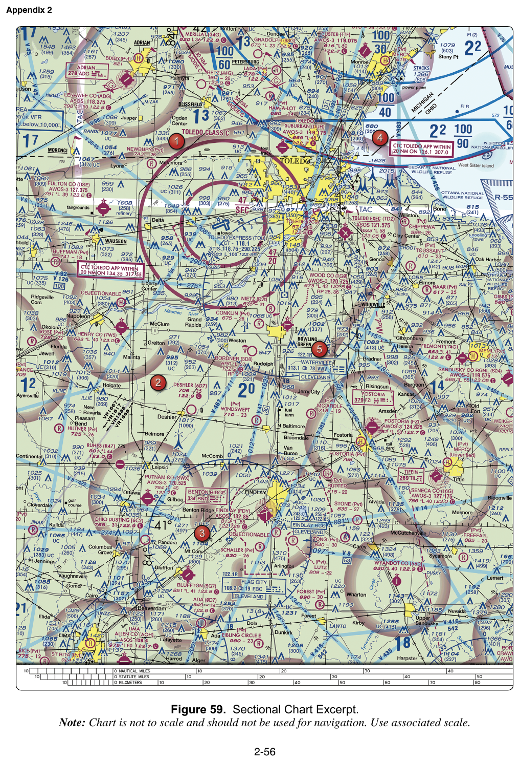
FAA-CT-8080-2H Figure 59. The gray lines marked VR1667, VR1617, VR1638 are Military Training Routes — a standard exam identification.
Key Terms
- Class G
- Uncontrolled airspace extending from the surface to the floor of the overlying controlled airspace.
- Alert Area
- Airspace depicting a high volume of pilot training or an unusual type of aerial activity where all pilots are responsible for collision avoidance.
- Warning Area
- Airspace identified by a W- number, generally over international waters, warning nonparticipating aircraft of potentially hazardous activity.
- Prohibited Area
- Airspace identified by a P- number where aircraft flight is prohibited.
- Restricted Area
- Airspace identified by an R- number containing unusual, often invisible hazards; entry requires authorization from the controlling agency when the area is active.
- Class E surface area
- Class E airspace that begins at the surface, depicted on a sectional by a dashed magenta boundary. Part 107 operations within it require prior ATC authorization under 14 CFR 107.41.
- Airport Advisory Area
- An area generally within a 10-statute-mile radius of an airport with FSS local airport advisory service, extending from the surface to 10,000 feet MSL.
- Controlled Firing Area
- An area where hazardous activities are suspended immediately when surveillance detects an aircraft entering the area; CFAs are not charted.
- National Security Area
- An area where pilots are requested to voluntarily avoid flight for national-security reasons; mandatory restrictions may be imposed if needed.
- Class E transition area
- Class E airspace that begins above the surface, commonly at 700 feet AGL or 1,200 feet AGL, supporting IFR transitions to and from airports.
- Military Training Route
- A route used by military aircraft for low-altitude training. IR routes are IFR routes and VR routes are VFR routes.
- Military Operations Area
- Airspace established to separate certain military training activities from IFR traffic; VFR operations may enter but should exercise extreme caution.
- Terminal Radar Service Area
- A radar-service area around certain airports. It is not an airspace class; the underlying airspace classification determines Part 107 authorization requirements.