 Skarp
SkarpChapter 6 of 23
Sectional Charts and Controlled Airspace
A colored boundary, faded vignette, or airport data block can determine whether a planned launch requires FAA authorization. This chart lab develops the visual decoding skills behind the exam’s highest-frequency airspace questions.
Start With the Authorization Question
The Part 107 rule
Prior ATC authorization is required in Class B, Class C, Class D, and within the lateral boundaries of a Class E surface area designated for an airport.
Do not answer from the airport alone
An airport symbol is evidence to investigate, not the final answer. Place the launch point against the depicted airspace boundary and layer before deciding.
Reliable reading sequence
- Locate the operation. 2. Find boundaries. 3. Decode altitudes. 4. Check airport data. 5. Decide whether prior authorization is required.
Build a Sectional Chart Reading Toolkit
Use the legend
The sectional chart legend is part of the problem-solving tool. It translates line style, color, airport symbols, obstacle labels, and altitude notation.
Measure in nautical miles
Use the chart scale to measure from your point to a boundary or airport. 1 NM is about 1.15 statute miles; do not mix the units.
Airport color is a clue
A blue airport symbol generally indicates a control tower; magenta generally indicates no tower. Airspace class still comes from the depicted boundary, not symbol color alone.
Decode Vertical Limits: MSL, AGL, SFC, and Hundreds
Chart numbers are hundreds of feet MSL
`40` means 4,000 feet MSL. `100/40` means 10,000 feet MSL on top and 4,000 feet MSL on the bottom. Read the numbers before applying Part 107.
Convert using terrain elevation
If terrain is 1,300 feet MSL, a flight at 400 feet AGL is 1,700 feet MSL. Compare that result to any charted airspace floor.
Read obstruction labels twice
`1527 (203)` means the obstruction top is 1,527 feet MSL and it rises 203 feet AGL above its local terrain.
Recognize Class B: Solid Blue Shelves
Visual signature
Solid blue lines depict Class B. The shape is often a collection of shelves, not one simple circle, and each shelf can have a different floor.
Read top over bottom
A label `100/40` means Class B from 4,000 to 10,000 feet MSL. The operation may be below a shelf even while it is laterally inside its outline.
Surface shelf changes the answer
`100/SFC` reaches the ground. A Part 107 launch inside that lateral area is in Class B and requires prior ATC authorization.
Work a Class B Shelf Problem
Given facts
The launch is within a solid-blue outline labeled `100/40`. Terrain is 1,200 feet MSL, and the planned maximum is 400 feet AGL.
Calculate the flight altitude
The aircraft reaches 1,600 feet MSL: 1,200 feet terrain elevation plus 400 feet AGL. The shelf floor is 4,000 feet MSL.
Answer and contrast
The operation is below that shelf. But an inner area labeled `100/SFC` starts at ground level, so the same flight there requires prior ATC authorization.
Recognize Class C: Solid Magenta Core and Shelf
Visual signature
Solid magenta lines depict Class C. Look for a surface-area core plus an outer shelf; the outer shelf may begin above the ground.
Class C labels remain MSL
`40/12` means 4,000 feet MSL on top and 1,200 feet MSL on the bottom. It never means a 1,200-foot AGL floor.
Authorization decision
Inside the Class C surface core, authorization is required. Under an outer shelf, calculate the aircraft's MSL altitude before deciding whether it enters the layer.
Recognize Class D and Read the Airport Data
Visual signature
Dashed blue lines depict Class D. A boxed blue ceiling value of `25` means the ceiling is 2,500 feet MSL.
Surface-based airspace
Class D normally begins at SFC. A launch within its active dashed-blue lateral boundary is therefore in Class D from takeoff.
Use data blocks correctly
Airport elevation is MSL. Tower and frequency data provide context, but a towered-airport symbol alone does not replace checking the Class D boundary and current status.
Separate Surface Class E From Class E Transition Areas
The authorization-specific Class E
A dashed magenta boundary depicts a surface area of Class E designated for an airport. Part 107 operations within it require prior ATC authorization.
Faded magenta is not surface Class E
A faded magenta vignette marks Class E beginning at 700 feet AGL. It is a transition area, not a Class E surface area.
Faded blue begins even higher
A faded blue vignette marks Class E beginning at 1,200 feet AGL. At a normal 400-foot AGL sUAS altitude, it is above the aircraft.
Multi-Layer Chart Lab: Choose the Correct Launch Point
Site A: dashed magenta
A dashed magenta boundary is a Class E surface area designated for an airport. Site A requires prior ATC authorization.
Site B: faded magenta only
Class E begins at 700 feet AGL, while the planned flight reaches 400 feet AGL. No authorization is triggered by that vignette alone.
Site C: calculate before answering
A `40/18` Class C shelf begins at 1,800 feet MSL. The flight reaches 1,900 feet MSL, enters Class C, and requires authorization.
Your 30-Second Chart Decision Routine
Pause and run the routine
Imagine your launch pin is near a towered airport. You see a blue airport symbol, a faded magenta vignette, and a dashed blue boundary two nautical miles away. Do not choose an answer yet.
Use this checklist aloud:
- Where is the launch and flight area? Mark the actual point, not the airport.
- What boundary encloses it? Solid blue, solid magenta, dashed blue, dashed magenta, or only faded shading?
- Does the relevant layer start at the surface or above it? Decode `SFC`, top/bottom labels, and MSL versus AGL.
- Will the planned altitude enter that layer? Convert 400 feet AGL to MSL if an elevated shelf is involved.
- What is the legal result? Prior authorization is required only if the operation is in Class B, C, D, or a Class E surface area designated for an airport.
For the imagined scene, the towered-airport symbol and faded magenta shading do not establish Class D at the launch. If the launch point is outside the dashed blue boundary and only under the 700-foot-AGL vignette, the chart facts given do not create an airspace authorization requirement. This is the same logic to use under time pressure.
Quiz 1: Identify the Authorization Trigger
A planned Part 107 flight will remain at or below 400 feet AGL. The launch site is within a faded magenta vignette but outside every solid or dashed controlled-airspace boundary. What does the vignette mean for this flight?
Which answer is best?
- Prior ATC authorization is required because all Class E airspace requires it.
- Prior ATC authorization is required because faded magenta depicts Class E at the surface.
- The vignette depicts Class E beginning at 700 feet AGL, so it does not by itself require authorization for this 400-foot AGL flight.
- The vignette depicts Class D airspace that begins at 700 feet MSL.
Show Answer
Answer: C) The vignette depicts Class E beginning at 700 feet AGL, so it does not by itself require authorization for this 400-foot AGL flight.
Faded magenta depicts Class E beginning at 700 feet AGL. Under 14 CFR 107.41, the relevant Class E trigger is the surface area of Class E designated for an airport, depicted with a dashed magenta boundary. A 400-foot AGL flight stays below the 700-foot-AGL transition area.
Quiz 2: Solve the Shelf Calculation
A launch site is laterally inside a solid-blue Class B shelf labeled `90/30`. Terrain elevation at the launch point is 2,400 feet MSL. The planned flight is 400 feet AGL. Does this particular Class B shelf require prior ATC authorization for the planned altitude?
Choose the best answer.
- Yes. Any location inside a solid-blue outline is automatically in Class B from the surface.
- Yes. The drone will reach 2,800 feet MSL, which is above the 900-foot Class B ceiling.
- No. The drone will reach 2,800 feet MSL, below the 3,000-foot MSL floor of this Class B shelf.
- No. Class B authorization is needed only above 400 feet AGL.
Show Answer
Answer: C) No. The drone will reach 2,800 feet MSL, below the 3,000-foot MSL floor of this Class B shelf.
`90/30` means a ceiling of 9,000 feet MSL and a floor of 3,000 feet MSL. The planned altitude is 2,400 + 400 = 2,800 feet MSL, below the shelf floor. The operation is laterally inside the outline but vertically below this layer. Option 1 ignores the charted floor, and option 4 is not the rule.
Flashcards: High-Frequency Chart Cues
Flip each card, then practice saying the authorization result as well as the chart meaning.
- Solid blue boundary
- Class B airspace. Read each shelf's top and floor in hundreds of feet MSL. Prior ATC authorization is required only when the operation is in the Class B layer.
- Solid magenta boundary
- Class C airspace. The core may begin at the surface; an outer shelf can begin above the surface. Prior ATC authorization is required when operating in Class C.
- Dashed blue boundary
- Class D airspace. It normally begins at the surface and is commonly associated with an operating control tower. Prior ATC authorization is required when it is in effect.
- Dashed magenta boundary
- A surface area of Class E airspace designated for an airport. This is the Class E configuration that triggers the Part 107 prior-authorization requirement.
- Faded magenta vignette
- Class E begins at 700 feet AGL. It is not a surface Class E boundary and does not by itself require Part 107 airspace authorization.
- `40/12`
- Top is 4,000 feet MSL; floor is 1,200 feet MSL. Convert the planned AGL altitude to MSL before deciding whether the aircraft enters the layer.
- `1527 (203)` obstruction label
- Obstacle top elevation is 1,527 feet MSL. The obstacle height above local ground is 203 feet AGL.
Figure 20 — Sectional chart excerpt (Savannah)
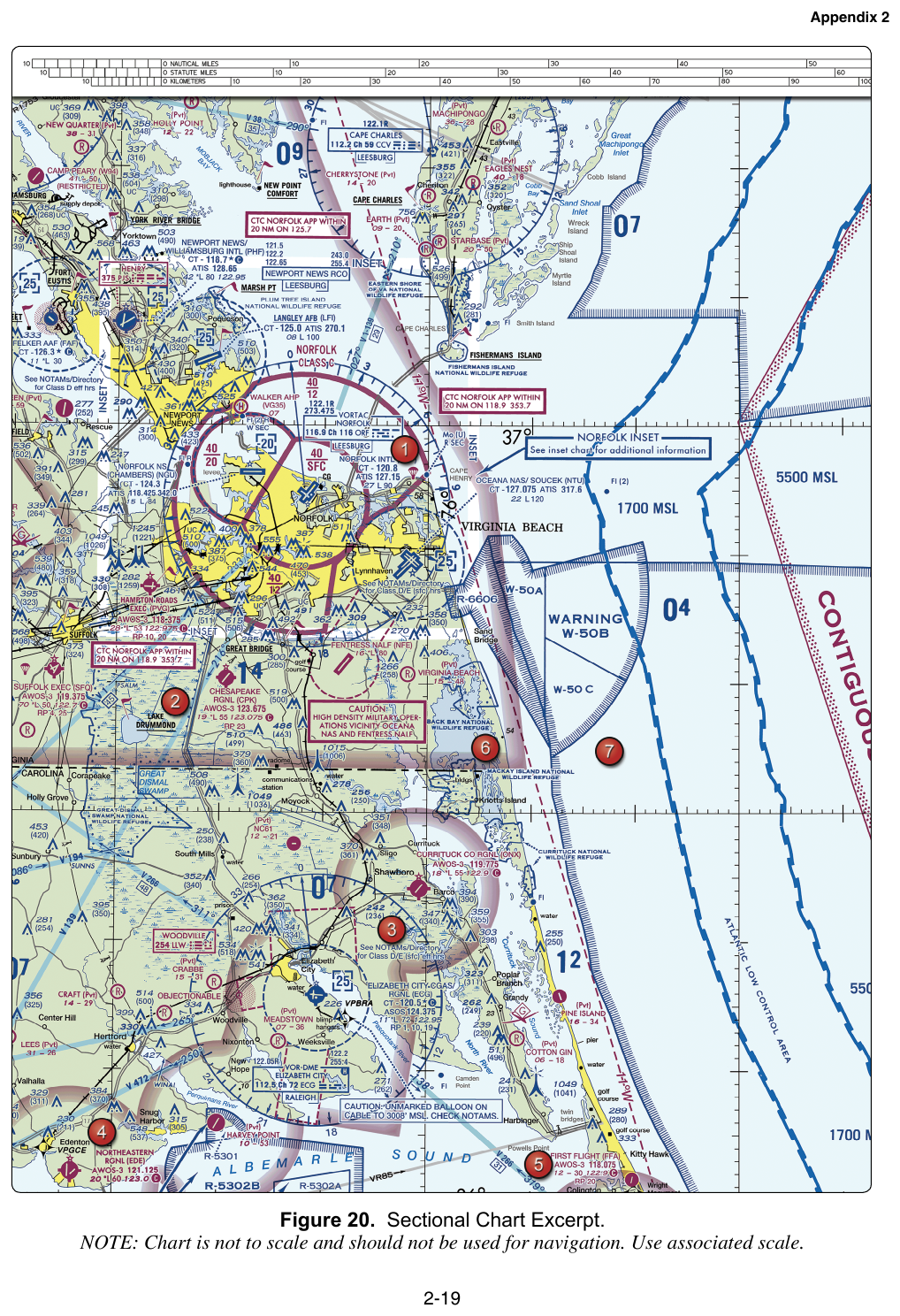
FAA-CT-8080-2H Figure 20. Exam questions read Class C shelf floors and the CHECK NOTAMS caution box from this excerpt.
Figure 23 — Sectional chart excerpt
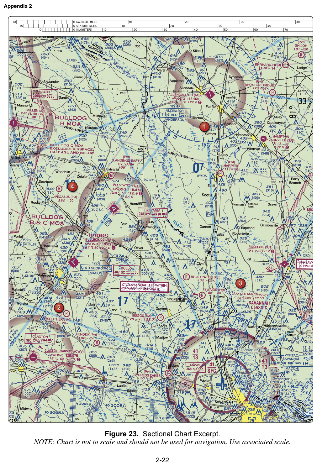
FAA-CT-8080-2H Figure 23. Practice locating airspace rings and shelf floors — the exam asks for the Savannah Class C outer-shelf floor here.
Key Terms
- SFC
- Surface; the airspace layer begins at the ground.
- vignette
- Faded sectional-chart shading that depicts where Class E transition airspace begins, such as 700 feet AGL for magenta or 1,200 feet AGL for blue.
- sectional chart
- A VFR aeronautical chart that depicts airspace, airports, terrain, obstructions, navigation information, and other planning data.
- Class B airspace
- Controlled airspace depicted by solid blue boundaries and arranged in one or more shelves with charted MSL floors and ceilings.
- Class C airspace
- Controlled airspace depicted by solid magenta boundaries, commonly consisting of a surface core and an outer shelf.
- Class D airspace
- Controlled airspace depicted by dashed blue boundaries, commonly around an airport with an operating control tower.
- Class E surface area
- A surface area of Class E airspace designated for an airport, depicted by a dashed magenta boundary.
- mean sea level (MSL)
- An altitude reference measured from mean sea level.
- prior ATC authorization
- Authorization that a Part 107 remote pilot must obtain before operating in Class B, Class C, Class D, or within the lateral boundaries of a Class E surface area designated for an airport.
- above ground level (AGL)
- A height reference measured from the terrain or surface directly below the aircraft.