 Skarp
SkarpChapter 16 of 23
Airport Layouts, Traffic Patterns, Lighting, and Security
Runway markings, windsocks, rotating beacons, approach lights, and radio calls all point to where manned aircraft are likely to appear next. Airport diagrams and realistic scenarios transform these clues into safe launch-site decisions.
1. Build an Airport Traffic Picture Before Launch
Airport awareness is predictive
An airport concentrates aircraft near the surface. Read markings, charts, lighting, winds, and radio calls as clues to where aircraft will move next, not merely where they are now.
Pre-launch sequence
Identify the facility, tower status, runways, published pattern, frequencies, obstacles, and remarks. Then compare that planned picture with actual winds, lights, aircraft, and observed activity.
Chart plus observation
A sectional and Chart Supplement show the airport's structure. Visual observation and monitored radio traffic reveal current operations. Use both before placing a small UAS near an airport.
Yield early
Manned aircraft may be descending, climbing, turning, hovering, or operating low. If a conflict develops, do not try to negotiate right-of-way from the air: descend, yield, and land when necessary.
2. Recognize Facility Types and Their Risks
Towered airports
Public-use towered airports generally use blue chart symbology. ATC sequences traffic, but arrivals, departures, taxiing aircraft, and helicopter routes can still create a dense and fast-changing environment.
Non-towered airports
Non-towered airports generally use magenta symbology. Pilots self-announce on CTAF and visually separate. Expect standard or published patterns, but also possible straight-in arrivals and varied radio discipline.
Heliports
A heliport uses an `H` symbol. Helicopters may hover, turn, arrive, or depart below fixed-wing pattern altitude. Their routes can be non-rectangular and their rotor wash can affect a small UAS launch site.
Seaplane bases
An anchor symbol identifies a seaplane base. Water, rather than pavement, is the operating surface. Expect changing wind-based directions, low-level climbs and descents, boats, docks, and shoreline hazards.
3. Decode Runway, Taxiway, and Sign Markings
Runway numbers
Runway numbers approximate magnetic heading rounded to the nearest 10 degrees with the zero removed. `18` means about 180 degrees magnetic; its reciprocal runway end is `36`. Parallel runways add `L`, `C`, or `R`.
Displaced thresholds
White arrows identify pavement leading to a displaced threshold. An arriving aircraft may not touch down before that threshold from that direction, even though the pavement can serve other limited operational purposes.
Chevrons and holding lines
Yellow chevrons identify a blast pad or unusable pavement, not extra runway. Two solid and two dashed yellow lines mark a runway holding position; stop before the solid-line side unless authorized.
Sign color matters
Red with white letters means a mandatory instruction. Black with yellow letters is a location sign. Yellow with black letters is a direction or destination sign. These colors communicate different levels of restriction.
4. Map the Traffic Pattern and Anticipate Aircraft
Five legs in order
Upwind follows takeoff; crosswind turns away; downwind parallels the runway opposite landing direction; base turns toward the runway; final aligns with it for descent and landing.
Standard is not universal
Left traffic is common, and a 45-degree entry to downwind is common at non-towered airports. They are not guarantees. The Chart Supplement can specify right traffic, altitude changes, or special procedures.
Predict vertical movement
Aircraft are typically climbing on upwind and departure paths, while they descend on downwind, base, and final. A UAS positioned beneath any of these areas can quickly lose vertical and lateral separation.
Do not ignore helicopters
Helicopters may arrive directly, fly low, hover, or use routes separate from fixed-wing traffic. The rectangular airplane pattern is a planning tool, not a boundary that contains all airport traffic.
5. Use Lighting, Windsocks, and Visual Approach Cues
Rotating beacons
A civilian land-airport beacon typically alternates white and green. Water airports use white and yellow; heliports use green, yellow, and white. A beacon identifies a facility but does not grant UAS access.
Runway-light orientation
Runway edge lights are normally white, with yellow near the end of many instrument runways. Threshold lights look green to an arriving pilot; runway-end lights look red when viewed from the runway.
Approach guidance
Approach-light systems lead to the threshold. On a PAPI, two red and two white lights indicate the normal glidepath. More white means high; more red means low. These show an active final-approach corridor.
Wind and local indicators
A windsock streams downwind; aircraft usually operate into the wind. Segmented circles and pattern indicators can reveal local traffic direction. Confirm these cues against charts, published data, and current observation.
6. Retrieve the Right Information from Charts and the Chart Supplement
Read the sectional first
For a site 1.2 NM from an airport, use the sectional to identify tower status, runway orientation, airport elevation, nearby obstacles, airspace, and printed frequencies. A chart symbol starts the analysis; it does not finish it.
Then read the Chart Supplement
Check runway dimensions and surface, lighting, CTAF and weather frequencies, traffic-pattern altitude and direction, obstacles, services, operating hours, and remarks. Remarks often contain the operational detail a map cannot show.
Turn wind into a prediction
With Runway 9/27 and wind from 260 degrees, Runway 27 may be favored. Arrivals may approach from the east; departures may climb westbound. Confirm actual runway use by observation and monitored communications.
Altitude is not a shield
A flight below 400 feet can still conflict with aircraft on approach, departure, or helicopter routes. If the job site is near a pattern leg or approach path, relocation, postponement, or coordination may be the safe choice.
7. Turn Radio Calls into a Mental Traffic Display
Decode the call
A call of "entering left downwind Runway 18" identifies both direction and likely next turns. For Runway 18, final traffic travels south. The pilot will normally turn from downwind to base, then final.
Locate the downwind
For a standard left pattern to Runway 18, downwind is normally east of the runway. The aircraft can be descending, preparing to descend, and turning toward the runway within a short time.
Avoid false precision
Being outside one named pattern leg does not prove safety. Patterns widen, aircraft go around, other traffic enters differently, and helicopters use separate routes. Pause or land when the traffic picture is uncertain.
Radio is supplementary
CTAF calls create early awareness, but not every aircraft transmits or reports perfectly. Continue visual scanning. Radio monitoring supports the remote pilot's see-and-avoid responsibilities; it does not replace them.
8. Protect Security Areas and Respond to Wildlife Hazards
SIDA access control
A Security Identification Display Area uses controlled access and identification procedures. Never tailgate, borrow credentials, or enter through a controlled gate without authorization. Airport security rules protect the entire aviation system.
Security is not the only boundary
A location outside a SIDA may still be a ramp, taxiway, runway, vehicle route, fueling area, or emergency route. Keep personnel and equipment out of movement areas and coordinate when airport operations could be affected.
Wildlife is dynamic
Birds gather near water, grass, crops, waste, and feeding periods around dawn or dusk. A flock can move suddenly. Do not fly through wildlife activity; land or delay when animals create a collision hazard.
After a strike
First protect people and evaluate the aircraft. Document time, location, species if known, damage, and safe photographs. Report through the FAA Bird/Other Wildlife Strike Report process, FAA Form 5200-7, as appropriate.
9. Launch-Site Decision Drill
Choose the safer plan
You are asked to photograph a construction site beside a non-towered airport. The site is 0.8 NM from the runway midpoint. The Chart Supplement shows Runway 18/36, right traffic for Runway 18, and a pattern altitude of 1,000 feet AGL. The windsock streams toward the south, indicating wind from the north. You hear an aircraft announce it is departing Runway 18, and you see another airplane approaching from the north at low altitude.
Work through the clues:
- Wind from the north favors operations into the wind, making Runway 36 more likely than Runway 18. But do not assume: verify observed runway use.
- The announced Runway 18 departure is actual, current evidence that traffic may be operating southbound despite the wind.
- Right traffic for Runway 18 puts the downwind leg west of the runway. A site near that side may be close to a pattern leg.
- An aircraft approaching from the north could be approaching Runway 18, departing after a maneuver, conducting a straight-in approach to Runway 36, or transiting. Its intent is uncertain.
Your decision: Do not launch until you resolve the conflict. Continue scanning and monitoring, observe runway direction, and move to a location clearly away from expected aircraft paths if the mission can be conducted safely. If the situation remains ambiguous, postpone. The best answer on both the exam and in practice is usually the one that creates more time, distance, and certainty.
10. Quiz: Pavement Markings
Select the best interpretation of the marking.
A paved area immediately before a runway threshold has large yellow chevrons. What should a remote pilot infer?
- It is a blast pad or similarly unusable paved area, not normal runway surface for takeoff, landing, or taxi.
- It is a displaced threshold and may be used as a landing touchdown area from the approach direction.
- It is a taxiway intersection where aircraft have priority over UAS.
- It is an approach-light system that identifies the active runway.
Show Answer
Answer: A) It is a blast pad or similarly unusable paved area, not normal runway surface for takeoff, landing, or taxi.
Yellow chevrons identify a blast pad or other area not intended for normal aircraft takeoff, landing, or taxi operations. A displaced threshold is identified by white arrows and related white runway markings, not yellow chevrons.
11. Quiz: Pattern Prediction
Use runway direction and pattern terminology to predict the highest-risk area.
At a non-towered airport, an airplane reports entering left base for Runway 27. Where is it most likely to appear next?
- On final approach, aligned westbound with Runway 27 and descending toward the threshold.
- On the upwind leg, climbing eastbound after departure.
- On right downwind, parallel to the runway eastbound.
- Taxiing on a taxiway toward the departure end.
Show Answer
Answer: A) On final approach, aligned westbound with Runway 27 and descending toward the threshold.
Runway 27 is oriented approximately 270 degrees magnetic, so landing traffic on final travels westbound. The base leg turns into final. An aircraft reporting left base is therefore likely to turn soon onto westbound final and continue descending.
12. Flashcards: Airport Clues to Recall
Flip each card, answer aloud, then connect the fact to a launch-site decision.
- What does Runway 18 indicate?
- A runway oriented approximately 180 degrees magnetic. The reciprocal end is Runway 36.
- What do yellow chevrons indicate?
- A blast pad or other pavement not intended for normal taxi, takeoff, or landing.
- What does a runway holding position marking look like?
- Two solid and two dashed yellow lines. Approaching from the taxiway, stop before the solid lines unless authorized to cross.
- Name the five standard traffic-pattern legs.
- Upwind, crosswind, downwind, base, and final.
- What does a windsock show?
- It streams downwind. The wind comes from the opposite direction, and aircraft generally take off and land into that wind.
- What does two red and two white PAPI lights mean?
- The approaching aircraft is on the normal visual glidepath.
- What is the usual civilian land-airport rotating beacon color combination?
- Alternating white and green.
- What is a SIDA?
- A Security Identification Display Area: a controlled airport security area requiring authorized access and identification procedures.
- What should follow an aircraft-wildlife collision?
- Protect people, assess damage, document relevant facts, notify appropriate airport personnel when needed, and report through the FAA Bird/Other Wildlife Strike Report process as appropriate.
Figure 26 — Sectional chart excerpt (Cooperstown)
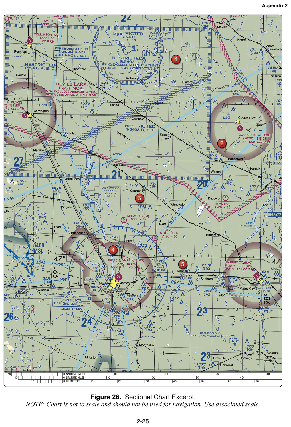
FAA-CT-8080-2H Figure 26. Cooperstown's CTAF, latitude lines, and tower obstructions — three sample-exam questions use this one excerpt.
Key Terms
- CTAF
- Common Traffic Advisory Frequency used by pilots to communicate airport advisory information, especially at non-towered airports.
- PAPI
- Precision Approach Path Indicator, a visual glidepath system in which two red and two white lights normally indicate on-glidepath.
- SIDA
- Security Identification Display Area, a controlled airport security area with access and identification requirements.
- final
- The traffic-pattern leg aligned with the landing runway, normally flown while descending toward the threshold.
- base leg
- The traffic-pattern leg flown between downwind and final.
- heliport
- An airport or landing area intended for helicopter operations.
- blast pad
- A paved area near a runway end intended to reduce erosion from jet blast; yellow chevrons indicate it is not normal operating pavement.
- seaplane base
- An operating area on water used by seaplanes, commonly represented by an anchor symbol on aeronautical charts.
- traffic pattern
- The standardized path aircraft commonly fly around an airport for takeoff and landing operations.
- wildlife strike
- A collision between an aircraft and a bird or other wildlife.
- Chart Supplement
- FAA publication containing detailed airport and facility information, including runways, frequencies, traffic patterns, services, and remarks.
- displaced threshold
- A runway threshold located inward from the physical beginning of runway pavement; landing touchdown is not permitted before it from the approach direction.
- airport rotating beacon
- A rotating or flashing light beacon used to help identify an airport or heliport, with color combinations that vary by facility type.
- mandatory instruction sign
- A red sign with white inscription that identifies a runway-holding position, runway entry restriction, or other mandatory instruction.
- runway holding position marking
- Two solid and two dashed yellow lines marking where an aircraft must stop before entering a runway unless authorized.